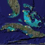
To the left is a graphic I put together from material I recently received from the good folks at Satellite Discoveries. It shows five newly discovered regions of linear patterns on the ocean floor. Four of these site are in Cuban waters and the fifth is off the tip of the Florida Keys. For more details and exact GPS coordinates, please visit the SD site at http://www.satellitediscoveries.com and scroll down to the New Additions section.
SD’s discoveries become even more fascinating when you view them in conjunction with the other item in the album, a relief map of the Caribbean. This map was taken from the CIA World Factbook (http://www.cia.gov/cia/publications/factbook/docs/refmaps.html) and it unintentionally provides a pretty good idea of what the Caribbean would have looked like 10,000 years ago, before the end of the last ice age. Graham Hancock (http://www.grahamhancock.com) and others believe that the oceans rose about 300 feet when the polar ice melted and that this event destroyed entire civilizations that had evolved in coastal areas. What’s interesting about the CIA map is that it puts all five of SD’s sites on dry land – either on an island, in a coastal area or, in the case of theFlorida site, well inland.
While the true nature of these linear patterns is not yet known, Satellite Discoveries has determined that the width of the lines in the photos is consistent with the width of roads! If they are roads, the underwater ruins known as MEGA may turn out to be just the tip of the iceberg (no pun intended) when it comes to Caribbean mysteries. Unfortunately, the Cuban sites are inaccessible to most of us, but the Florida site is only 90 to 110 feet deep and accessible with SCUBA gear. Who’s going to be the first to know what’s out there?

